Pilot sites
Following the design of the evacuation and refuge plan, we focused on three pilot sites. These are sites 1, 3 and 9, which we consider are representative of a larger situation. There are particular challenges and specific characteristics for each site, which define the type of solutions that we envision. We developed a plan for each site, combining a series of NbS and other complementary measures that aim at improving disaster evacuation and reducing flood risks.
Site 1
Analysis
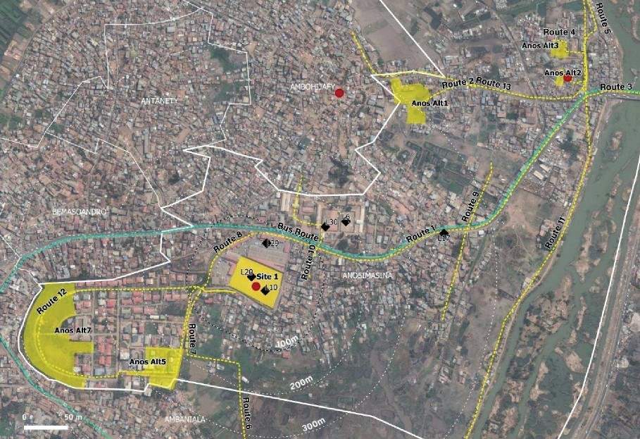
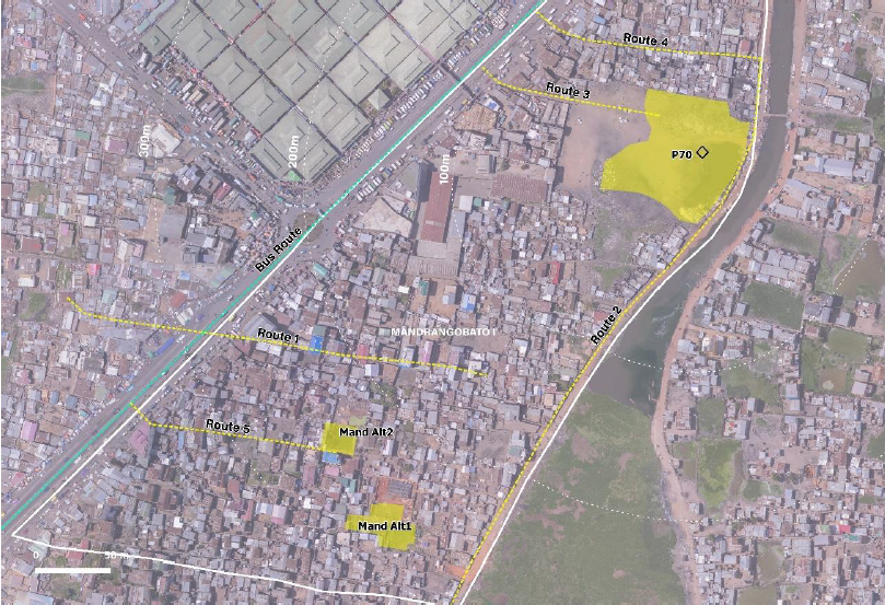
Site 1 is a refuge site indicated in the UNOCHA plan which is also commonly used by the community, making it a robust refuge option. Even though it is not in a flood-prone area, it is located next to one, so it can have a great impact on evacuation and refuge for the surrounding areas. In addition, it is in a part of the city that is not fully urbanized yet, so there is still great potential for the implementation of NbS. If unplanned urbanization continues, it could make this area more impermeable, preventing adequate infiltration and increasing runoff. In turn, this increases flood risk, especially in areas with lower elevation. Instead, if NbS are implemented, they can stir the process in a direction that decreases risks while maximizing opportunities.
According to these characteristics, we consider that the sense of urgency to implement solutions on this site is low. However, if we take into account the implementation times of NbS and the fact that if nothing is done, future urbanizations will reduce current opportunities for implementation, this is a good time to begin planning for flood resilient interventions in the area. We foresee a good integration of the proposed interventions with the existing evacuation plan from UNOCHA. Moreover, several potential alternative locations in the vicinity could be complementary.
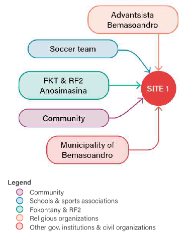
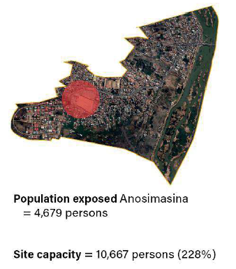
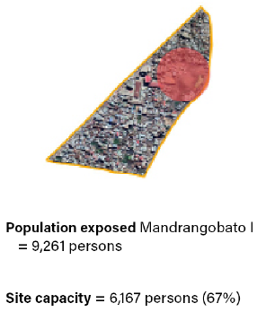
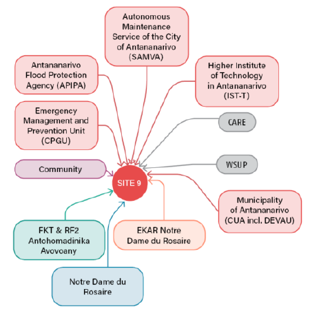
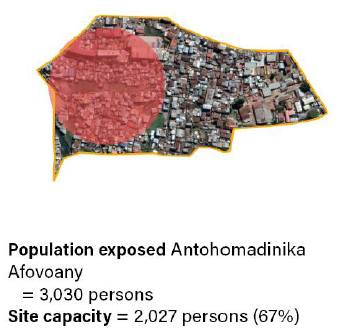
(left) Relevant stakeholders for site 1 on a city scale; (right) population exposed v/s refuge capacity of site 1
In terms of governance, there is a strong involvement of the community in organizing and implementing activities related to neighborhood improvement, even though the fokontany itself it is not very active. This shows the degree of community engagement, which is fundamental for the implementation and maintenance of measures at this location.
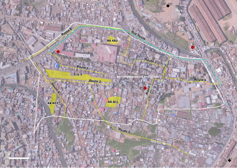
According to the household survey results, there is an early warning system in place, focused mainly on flooding. This gives people enough time to evacuate, so we consider an evacuation distance of no more than 500m to a refuge site. Besides the refuge in site 1, it is possible to recommend several other locations for on-site evacuation, although their suitability needs to be further study. During phase II of the evacuation plan, when this site is used for off-site refuge, these additional locations could accommodate the remaining people that exceed the capacity of site 1.
Plan
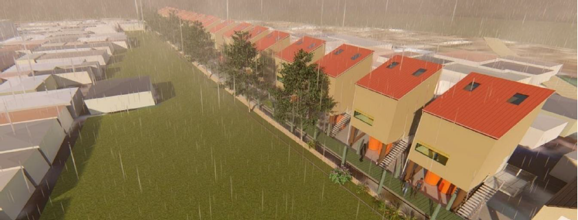
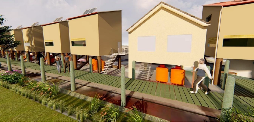
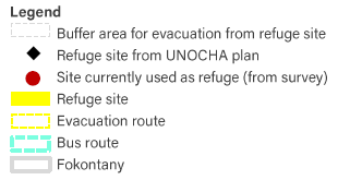
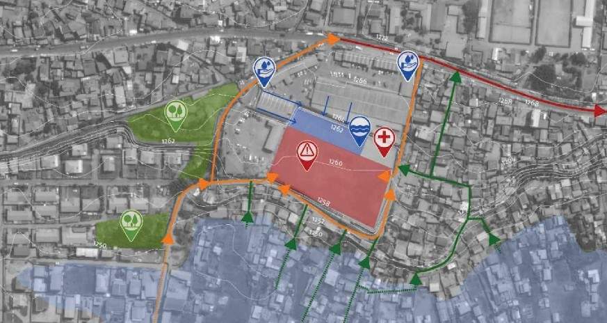
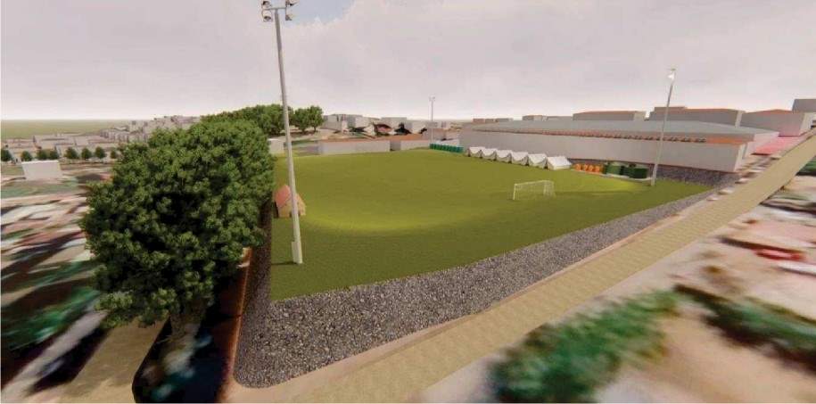
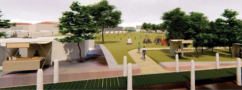
Site 1 is in a location that is not flood-prone, but its surrounding areas are. Considering the site characteristics, which include elevation difference, scarce public greenery, and the existence of a public sports facility, the strategy for this site is based on: managing the rainfall locally to reduce the effects of runoff in the surroundings; decrease erosion and landslide risks; and develop a network of safe evacuation routes. The priority is to store the water on-site for later use. When that is not possible, rainfall can be infiltrated slowly and as clean as possible to reduce the pollution of the subsurface. Finally, if storage and infiltration are not possible or not enough, the excess water can be drain to the swamps.
The plan includes the following NBS measures:

The plan aims to reduce flood risk by storing and infiltrating water on the site, by means of a retention pond, rain barrels, and increasing the vegetation cover (urban forests and trees). The latter also contributes to reduce landslide risks and reduce heat stress. It also aims to improve disaster evacuation and refuge by developing a network of safe evacuation routes that provide evacuation from the swampy areas towards safer higher areas.
The routes are elevated and well indicated with trees. In addition, we make use of popular recreation areas such as the soccer field, to boost awareness initiatives and develop a community-based implementation and maintenance arrangement. For example, the retention pond next to the soccer field could be used to generate awareness in the community about the benefits of rainwater harvest.
Site 3
Analysis
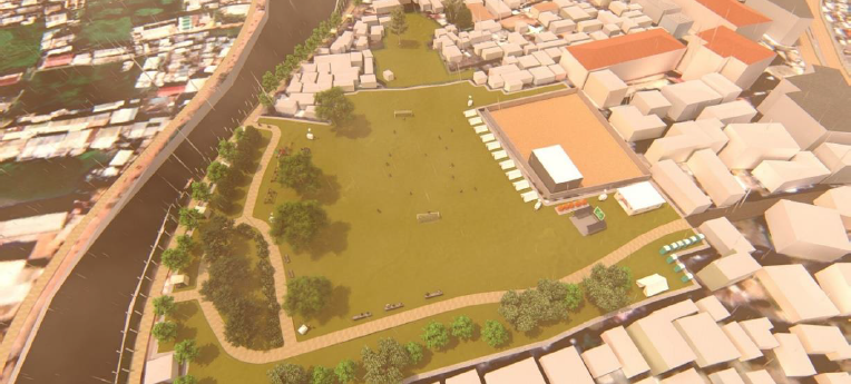
Site 3 has several similar characteristics to site 9, but with a distinctive additional opportunity: there is a large empty site with the potential of becoming a refuge site, next to a basin that will be dredged and renovated in the short term. We believe that including this site could be useful to provide recommendations for the renovation project that will take place in the basin. The site is located in a centrally-located, low-lying and very flood-prone urbanized area that suffers from increasing sanitation problems. In spite of its central location, accessibility in some areas within this site is poor. The groundwater level is shallow, so there is not a lot of space in the subsurface to store water.
After heavy rainfall, this causes the water to stagnate in multiple locations. There are some open spaces with the potential to be used for the implementation of NbS, but only one of them is large enough to be used as a refuge site. That site has a temporary use as a marketplace, but it has been urbanized in recent years. Given its strategic and central location, this site could serve several purposes, catering to the needs of a large group of people, both from Mandrangobato I as well as the surrounding fokontany. This site is also categorized as an assembly point in the UNOCHA plan.
According to these characteristics, we consider that the sense of urgency to implement solutions on this site is high. Drainage is not optimal, because of the unorganized disposition of the houses, the presence of solid waste in most existing ditches, and the subsurface characteristics. The increase in population (including migrants) could likely increase the production of solid waste, worsening this problem.
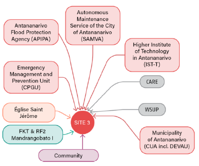
In terms of governance, there is a strong engagement of the community and local institutions which is fundamental for the implementation and maintenance of measures at this location. The fokontany of Mandrangobato I is active and committed, as well as the RF2, and the population is aware of the existing risks and interested in improving their current environment.
The household survey did not cover this area. However, based on survey responses from nearby areas together with the two workshops, it is possible to identify other potential evacuation routes and alternative refuges within a radius of 300m that could accommodate part of the exposed population, although their suitability needs to be studied further. The main evacuation route that is also a bus route is located no more than 200m from all the propose refuge sites. During phase I of the evacuation plan, this site can be used for refuge. However, during phase II people would need to evacuate to other safer locations.
Plan
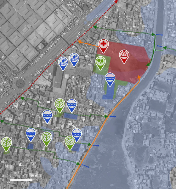
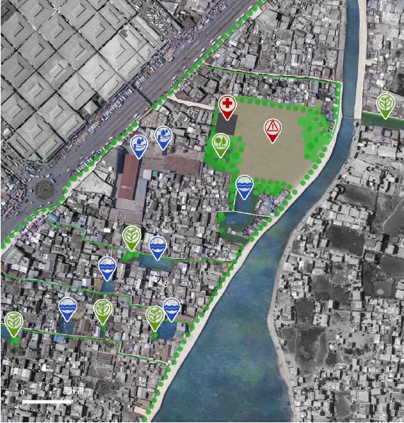
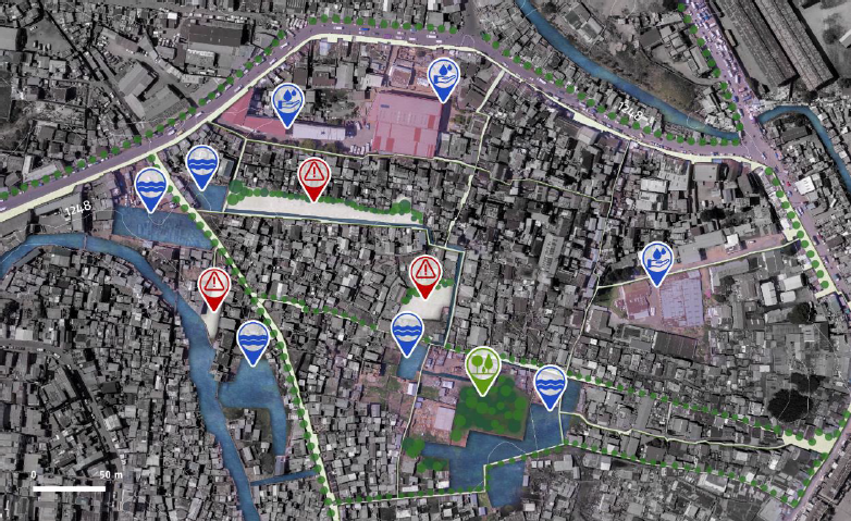
Site 3 is in a location that is flood-prone, as well as its surroundings. Considering the site characteristics, which include minimal elevation difference, scarce public-use greenery and the existence of a multipurpose open space, the strategy focuses on: managing rainfall locally to mitigate the impact of floods and develop a network of safe evacuation routes. The priority is to increase surface water storage complemented by the upgrading of the drainage system towards the Anosibe basin.
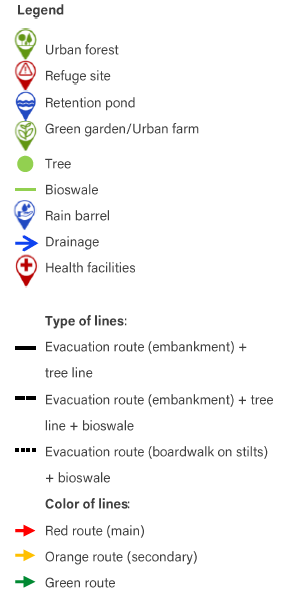
The plan includes the following NBS measures:
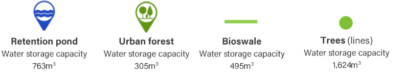
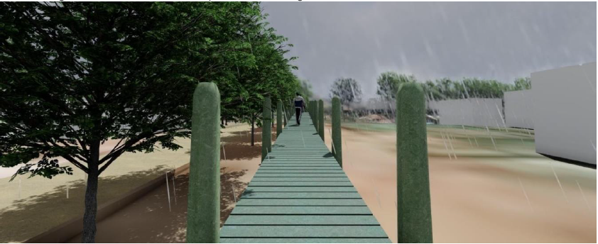
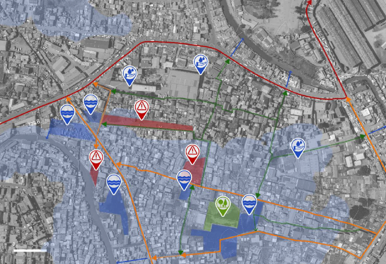
The plan aims to reduce flood risk by increasing the surface water storage capacity of the site using retention ponds at different locations together with bioswales to slowly infiltrate rainfall as clean as possible or alternatively conveying surface runoff towards the Anosibe basin. The overall increase of the surface covered by water and vegetation, using bioswales, lines of trees, urban forests and private gardens also contributes to reduce heat stress. In addition, trees are used to delineate refuge areas, preventing further encroachment. The main evacuation routes (red and orange) and refuges are elevated and delineated by trees, so they are clearly visible and safe during phase I of the evacuation. The secondary routes (green) are elevated on stilts, with a bioswale next to them which allows the free flow of water in case of extreme floods. A robust governance structure should be developed for the implementation and maintenance of NbS at these locations, that combines the local institutions and the community. Interventions on this site make use of a well-connected area, that is popular and easily recognizable by the community, as a refuge site. By implementing multiple and compatible programs that combine basic services (e.g. medical facilities, disaster evacuation) with temporary uses (e.g. hawker stalls, recreation), a robust governance structure should be developed to ensure the implementation and maintenance of the measures at this location.
Site 9
Analysis
Site 9 is located in a flood-prone, well connected and densely urbanized area, that suffers from sanitation problems and where there is an urgent need to provide safe and expedite disaster evacuation, but few opportunities to do so. These opportunities are threatened by the ongoing encroachment and the insufficient infrastructure, such as bridges in poor condition to cross the C3 canal. Drainage is not optimal, because of the unorganized disposition of the houses, the presence of solid waste in most existing ditches, and the subsurface characteristics with shallow groundwater levels. The increase in population could likely increase the production of solid waste, worsening the problem. Strategic measures at this point could have a positive impact on disaster evacuation and flood risk reduction. There some open spaces with the potential to be used for the implementation of
NbS, but this constantly changes due to the increasing densification of the area by means of informal settlements, including migrants from other regions of the country. According to these characteristics, we consider that the sense of urgency to implement solutions on this site is high.
In terms of governance, there is no information about the level of engagement and participation of the fokontany and RF2. However, we identified several potentially relevant institutional stakeholders, such as religious and educational organizations.
According to the household survey results, there are several locations currently used as refuge in a radius of 300m. The main refuge together with the alternative refuges have the adequate capacity to accommodate the population exposed in this fokontany during phase I of evacuation. However, during phase II people would need to evacuate to other safer locations.
Plan
Site 9 is in a location that is flood-prone, as well as its surroundings. Considering the site characteristics, which include minimal elevation difference, scarce open spaces and public greenery, the strategy focuses on: managing rainfall locally to mitigate the impact of floods and develop a network of safe evacuation routes. The priority is to increase surface water storage complemented by the upgrading of the drainage system towards the C3 and the Adriantany canals, and develop a network of safe evacuation routes.
The plan includes the following NBS measures:
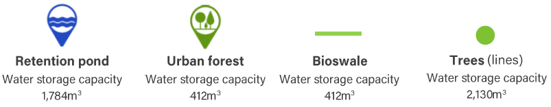
The plan aims to reduce flood risk by increasing the surface water storage capacity of the site using retention ponds at different locations together with bioswales to slowly infiltrate rainfall when possible, otherwise conveying surface runoff towards the main canals. The overall increase of the surface covered by water and vegetation, using bioswales, lines of trees and urban forests also contributes to reduce heat stress. In addition, trees are used to delineate refuge areas, preventing further encroachment. The main evacuation routes (red and orange) and refuges are elevated and delineated by trees, so they are clearly visible and safe during phase I of the evacuation. The secondary routes (green) are elevated on stilts, with a bioswale next to them which allows the free flow of water in case of extreme floods. A robust governance structure should be developed for the implementation and maintenance of NbS at these locations, that combines the local institutions and the community